I am wondering if anyone could explain to me how to split coordinates into latitude and longitude captured through a commcare app: These are examples I copied from data exported into excel
If you are manipulating the data in excel, you can use the text to columns feature to extract the 4 elements into 4 columns, then use the CONCATENATE function to bring them back together with a comma.
To parse from a cell in this case H10:
Latitude =LEFT(H10,FIND(" ",H10,1)-1)
Longitude =MID(H10,FIND(" ",H10,1)+1,FIND(" ",H10,FIND(" ",H10,1)+1)-FIND(" ",H10,1))
If using a table simply replace the cell reference A1 with a field name like TableName[form.GPS].
I want to build the map on google maps from the coordinates. I have split the coordinates using text to columns method and combined the latitude and longitude through the concatenate function. Is any difference from keeping LAT and LONG in separate columns and keeping them in one column when it comes to map building?
Awesome ! Do you mind sharing how you're setting up the map in particular? Always interested to hear how people are using their data downstream, and other folks in the forum may be interested in the example.
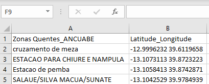
I followed your instructions to separate latitude, longitude, elevation and accuracy. After I eliminated elevation and accuracy columns. I combined lat. and long. columns into one and included another column with names of locations as shown below.
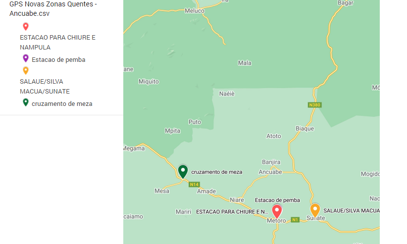
Having the csv excel file ready, I went to Google Maps and followed some steps:
On your computer, I opened Google My Maps.
I clicked on create a map.
In the map legend, I clicked Add layer.
I gave the new layer a name.
Under the new layer, I clicked Import.
I Chose or uploaded the csv excel file containing your info
I selected the columns from the file to put placemarks on the map ( I selected the LAT_LONG column)
I Picked a column to use as the title for the placemarks, here I selected the locations column person.
I had the info added on the map. (To have names of locations appear on the map, I defined labels (names in the column column)